Fort Street Bridge Park
 The Fort Street Bridge Park project transforms a neglected urban space in Detroit’s heaviest industrial area into a human-friendly gateway that interprets the history of labor, industry and environment and celebrates a new green corridor linking Detroit to downriver communities.
Fort-Rouge Gateway (FRoG) Collaborative meetings provided a forum for planning. Building on the legacy of the Rouge River Gateway Partnership, which contributed to significant environmental, social and economic improvements within the Rouge River gateway over the last decade, the FRoG Collaborative is focused on an area near the historic Fort Street Bridge as the site for this transformative place-making project. Stakeholders agreed that lack of access to natural areas is a major issue in post-industrial cities such as Detroit, and blue|green infrastructure is known to provide valuable ecosystem and community life support service, which became fundamental premises for this project.
Plans developed by the Michigan Department of Transportation (MDOT) to construct a new bridge at Fort Street, accommodating bicyclists and pedestrians, provided impetus for initial meetings. With the bridge now completed (in December of 2015), it offers passage for the Iron Belle Trail through southwest Detroit. Due to the historical significance of the former bridge, as it relates to the 1932 Hunger March, and its “bascule” style, and because of its crucial position at the intersection of three proposed or existing greenway systems (the Rouge Gateway Greenway, the Detroit Greenways and the Downriver Linked Greenways), this MDOT-owned, half-acre parcel offers a unique opportunity to achieve a momentous regional impact.
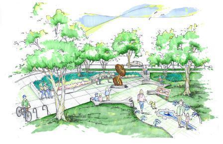
Ideas for the park arose from discussions among local community organizations, governmental agencies, businesses and higher education institutions having interest in the FRoG. PEA staff participated in the “idea phase” and assisted FRoG stakeholders to finalize conceptual plans for the pocket park, emphasizing the sites historical and ecological significance. A gathering plaza slated as the project’s first phase of development hosts organically structured seating, porous pavement, interpretative signage and an interactive stormwater management demonstration including a rain garden and native plantings. Sculptural and interpretive focal points within the plaza are constructed with salvaged materials from the former bridge. Interpretive signage narrates the history of the former bridge and the “Hunger March” of 1932, which was organized at this location and resulted in 5 deaths at the Rouge Plant when marchers met resistance. Signage also informs visitors about the environmental and industrial history of the region, including the importance of the waterways in providing the basis for early settlement and later industrial development.
The interactive stormwater demonstration informs visitors about the urban and natural water cycles. Water sprays can be actuated by visitors to demonstrate how the porous pavement system works. An interpretive panel describes the urban and natural water cycles and how a river’s health is benefited by subsurface flow verses over-land runoff. Increased awareness of these concepts can raise public demand for best management practices for handling stormwater on future land developments. Interpretation of our cultural past and the importance of our environment|water runs parallel with the park’s larger function as a new green linkage between Detroit and downriver communities – a connection that has been missing for nearly 100 years.
Public health and safety in the area will be enhanced. The proposed park offers a respite for walkers and bicyclists to get off of the road and out of traffic during times when the bridge is up due to passing freighters or any time as needed for a short rest. Lighting is included for after-sunset safety. Native trees, shrubs and perennials reinforce the notion that life exists along the corridor, easing mental and physical tensions potentially held by pass-through travelers.
This project aligns with the Detroit Future City (DFC) framework’s emphasis on enhanced blue and green infrastructure. It serves as a catalyst for implementing blue and green infrastructure projects along the Lower Rouge and Fort Street corridors using a collaborative model involving community, academia, industry and government. It also provides economically challenged, local community members with an opportunity to connect to the environment, giving them a stake in a new sustainable future for this region.
The Rouge River gateway will be enhanced by the addition of a new “green hub” in the heart of Detroit’s most industrialized area. Although the park’s footprint is small, its impact is leveraged by developments within the adjacent 100 acres known as Oakwood Heights, a former neighborhood undergoing transition to a multifunctional greenspace by Marathon Petroleum Company LP (MPC). MPC, a partial funder of the interpretive park, is committed to green redevelopment of Oakwood Heights that will be harmonious with the park’s design and purpose. Stay tuned for more about this developing greenspace…..